Hiking
Animas Mountain Trail System
The in-town summit just north of downtown. The main loop is a lollipop with the high point about halfway. The upper loop closes for wildlife from December 1 to April 15.
The upper loop closes for wildlife from December 1 to April 15.
- Length
- 5 miles
- Elevation gain
- 1428 ft
- Difficulty
- Advanced, Beginner, Expert, Intermediate
- From Durango
- 5 miles
Getting there
Main Trailhead (West 4th Avenue & 32nd Street) Birket Drive Trailhead To main trailhead: From North Main Street, turn left on 32nd Street and then a right on West 4th Avenue, where you will see the parking lot/trailhead for Animas Mountain a short ways up.
The trails
Each path in the system has its own tile. Length and climb sit underneath. Hover a tile for what the trail actually does. Pick a rating to see only those.
Intermediate
- IntermediateSwerve TrailSwerve is usually ridden with Merv, just north of Sailing Hawks in Dalla Mountain Park .
0.6 Miles · 265 Feet of climbing
Swerve is usually ridden with Merv, just north of Sailing Hawks in Dalla Mountain Park .
- IntermediateBirket TrailBirket is an intermediate climb of switchbacks from Birket Drive up to Animas Mountain Trail .
0.5 Miles · 130 Feet of climbing
Birket is an intermediate climb of switchbacks from Birket Drive up to Animas Mountain Trail .
- IntermediateX-Rock Climbing AreaRock climbing is easy to reach from town.
0.7 Miles · 465 Feet of climbing
Rock climbing is easy to reach from town.
- IntermediateAnimas Mountain Upper LoopAnimas Mountain is one of Durango's signature hikes, with views south into Hermosa and north into the Animas valley.
5.32 Miles · 1430 Feet of climbing
Animas Mountain is one of Durango's signature hikes, with views south into Hermosa and north into the Animas valley.
- IntermediateAnimas Mountain Lower LoopMap & Directions Map Coordinates: 37.317871, -107.865844 Where's the Trailhead.
1.9 Miles · 785 Feet of climbing
Map & Directions Map Coordinates: 37.317871, -107.865844 Where's the Trailhead.
Advanced
- AdvancedSick Bird TrailSick Bird stays alongside the eastern edge of the main Animas Mountain Trail loop.
1.7 Miles · 1020 Feet of climbing
Sick Bird stays alongside the eastern edge of the main Animas Mountain Trail loop.
- AdvancedMerve TrailMerv is usually ridden with Swerve, just north of Sailing Hawks in Dalla Mountain Park .
0.2 Miles · 60 Feet of climbing
Merv is usually ridden with Swerve, just north of Sailing Hawks in Dalla Mountain Park .
Where it is
The pin marks the trailhead. Map data © OpenStreetMap contributors.
Trail layout
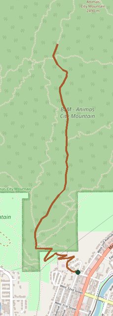
Trail layout from OpenStreetMap. The line is the mapped path that matched this name. A large system may show one path, not every loop. Map data © OpenStreetMap contributors.
Length and climb come from Durango Trails. A system with several trails lists each one above.