Hiking
Church Camp Trail System
Gentler trails on the edge of town, the easier alternative to the steeper in-town systems.
- Length
- 5 miles
- Elevation gain
- About 200 to 340 feet, depending on the trail
- Difficulty
- Advanced, Beginner, Intermediate
- From Durango
- 6.5 miles
Getting there
Church Camp/Falls Creek Parking Area To main trailhead: From Durango, drive west on 25th Street which turns into Junction Creek Road. At the three-way intersection go right (CR 205), pass Chapman Lake on the right side of road and park in the pullout past the National Forest sign; marked by a large boulder and gravel pull out. From here the trail heads to the east at the boulder and through the meadow towards Falls Creek. If this parking spot is full, there are several other small pull-outs along CR 205.
The trails
Each path in the system has its own tile. Length and climb sit underneath. Hover a tile for what the trail actually does. Pick a rating to see only those.
Beginner
- BeginnerChurch Camp LoopChurch Camp Loop is a popular trail route in the Church Camp/Falls Creek area.
1.4 Miles · 340 Feet of climbing
Church Camp Loop is a popular trail route in the Church Camp/Falls Creek area.
Intermediate
- IntermediateRidge Hike TrailThe Ridge Hike Trail is an out-and-back trail option in the Church Camp trails area.
1.3 Miles · 200 Feet of climbing
The Ridge Hike Trail is an out-and-back trail option in the Church Camp trails area.
Where it is
The pin marks the trailhead. Map data © OpenStreetMap contributors.
Trail layout
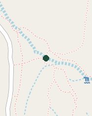
Trail layout from OpenStreetMap. The line is the mapped path that matched this name. A large system may show one path, not every loop. Map data © OpenStreetMap contributors.
Length and climb come from Durango Trails. A system with several trails lists each one above.