High Country Trails
Highland Mary Lakes
Reaching the spectacular high alpine tundra of the Weminuche Wilderness usually requires a multi-day backpacking trip.
The Highland Mary Lakes trail is an exception, providing day hikers quick access to this alpine wonderland.
- Length
- 3 Miles
- Climb
- 1500 Feet
- Difficulty
- Advanced
- From Durango
- 57 Miles
Getting there
Highland Mary Lakes / Cunningham Gulch Trailhead. Begin at Main Avenue and 9th Street, then go west on 9th Street, toward Camino Del Rio (Highway 550). Make a right onto Camino Del Rio (Hwy 550) and continue north on Hwy 550 past Purgatory Resort toward Silverton. Drive northeast through Silverton on Greene Street, the town’s main street, pass the courthouse (on the left) and bear right on County Road 2 toward Howardsville. The road is paved for the first 2.0-miles and then turns to a good gravel surface. Just before reaching Howardsville, turn right on County Road 4 (marked with a sign for the Old One Hundred Mine Tour). Follow CR 4, a good dirt road, for 3.7 miles up Cunningham Gulch to the ruins of a mine. Note: County Road 4 splits part-way up Cunningham Gulch. Either road will get you to the trailhead. The road to the right (lower road) is easier. Hikers in low clearance vehicles should park off the road near the mine and walk up the road about 0.8 miles, gaining about 380-ft., to the trailhead. If walking the road, add 1.6 miles to the round-trip to the trail distance. The road crosses a bridge and then starts climbing up the right (west) side of the creek with the aid a long switchback. (The road gets rougher as it climbs, but is still OK for high clearance vehicles). Follow the road for a little over 0.8 miles to an intersection with a road splitting off to the left. If you are in a high clearance 2WD vehicle continue past this intersection to an obvious parking spot on your left. Those with 4WD can turn left, following the road downhill and across the creek. The trailhead parking lot is just beyond the crossing. Use care during periods of high water.
Where it starts
The pin marks an end of the mapped trail. Map data © OpenStreetMap contributors.
Trail layout
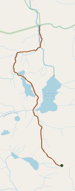
The line is the mapped path. Map data © OpenStreetMap contributors.