Hiking
Fort Lewis Trail System
Trails on the Fort Lewis College mesa, with short options for different ages and fitness. The Skyline and Lion's Den are the names locals use.
- Length
- About 13 miles if you add up the trails that list a distance
- Elevation gain
- Climbs run from about 100 to 1,050 feet
- Difficulty
- Advanced, Beginner, Expert, Intermediate
- From Durango
- 2 miles
Getting there
Chapman Hill Parking Lot FLC Stadium Parking Lot Lions Den Ball Lane Sky Ridge Parking Lot 10th Street.
The trails
Each path in the system has its own tile. Length and climb sit underneath. Hover a tile for what the trail actually does. Pick a rating to see only those.
Beginner
- BeginnerBall LaneBall Lane sits just off Florida Road in Durango.
0.3 Miles
Ball Lane sits just off Florida Road in Durango.
- BeginnerNature TrailThe Nature Trail at Fort Lewis is a mile-long trail and it joins Fort Lewis College and Durango.
0.5 Miles · 265 Feet of climbing
The Nature Trail at Fort Lewis is a mile-long trail and it joins Fort Lewis College and Durango.
- BeginnerLion’s Den TrailLion’s Den Trail is a on the easier side trail, a good fit for kids.
1.3 Miles · 725 Feet of climbing
Lion’s Den Trail is a on the easier side trail, a good fit for kids.
- BeginnerRim TrailFort Lewis Trail/Rim Trail can be accessed by climbing from the bottom of Chapman Hill or driving up to the top of...
2.9 Miles · 415 Feet of climbing
Fort Lewis Trail/Rim Trail can be accessed by climbing from the bottom of Chapman Hill or driving up to the top of...
- BeginnerChapman Hill Kid’s Up-Down TrailThe kids' up-and-down lines are at the bottom of Chapman Hill, an easy flow course where local and visiting kids...
0.2 Miles · 100 Feet of climbing
The kids' up-and-down lines are at the bottom of Chapman Hill, an easy flow course where local and visiting kids...
- BeginnerSky StepsDurango’s SkySteps opened to the public in June 2017, creating a town to sky connect from Durango to the Fort...
0.15 Miles · 250 Feet of climbing
Durango’s SkySteps opened to the public in June 2017, creating a town to sky connect from Durango to the Fort...
Intermediate
- IntermediateSquawker, Talker and Shocker TrailsSquawker, Talker, and Shocker are short links beside the Fort Lewis College Rim Trail.
1.1 Miles · 100 Feet of climbing
Squawker, Talker, and Shocker are short links beside the Fort Lewis College Rim Trail.
- IntermediateLamppost TrailLamppost Trail at Fort Lewis is a short trail from the 8th Street hill up to College.
0.3 Miles · 125 Feet of climbing
Lamppost Trail at Fort Lewis is a short trail from the 8th Street hill up to College.
- IntermediateBread Express TrailBread Express Trail sits off of Ball Lane.
0.4 Miles · 140 Feet of climbing
Bread Express Trail sits off of Ball Lane.
- IntermediatePowerline TrailPowerline Trail can be accessed either from Horse Gulch Road or Chapman Hill Ice Rink off Florida Road.
2.4 Miles · 355 Feet of climbing
Powerline Trail can be accessed either from Horse Gulch Road or Chapman Hill Ice Rink off Florida Road.
- IntermediateChapman Hill TrailChapman Hill Trail is a moderate connecting trail at the base of Chapman Hill to the top of Fort Lewis mesa.
0.2 Miles · 385 Feet of climbing
Chapman Hill Trail is a moderate connecting trail at the base of Chapman Hill to the top of Fort Lewis mesa.
Advanced
- AdvancedSkyline TrailSkyline Trail is a great there and back trail with an option to loop into Horse Gulch trail system .
3.1 Miles · 1056 Feet of climbing
Skyline Trail is a great there and back trail with an option to loop into Horse Gulch trail system .
- AdvancedChapman Hill Jump & Flow LinesThe jump and flow lines are also at the base of Chapman Hill.
0.3 Miles · 150 Feet of climbing
The jump and flow lines are also at the base of Chapman Hill.
Where it is
The pin marks the trailhead. Map data © OpenStreetMap contributors.
Trail layout
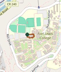
Trail layout from OpenStreetMap. The line is the mapped path that matched this name. A large system may show one path, not every loop. Map data © OpenStreetMap contributors.
Length and climb come from Durango Trails. A system with several trails lists each one above.