Hiking
Grandview Ridge Trail System
South of town and tied into Horse Gulch. Big Canyon is the usual way in off Highway 160.
- Length
- About 25 miles across the trails that list a distance
- Elevation gain
- Most climbs fall between 260 and 700 feet
- Difficulty
- Advanced, Beginner, Expert, Intermediate
- From Durango
- 5 miles
Getting there
Carbon Junction Trailhead Grandview Trails can be accessed at Big Canyon Trailhead or Sale Barn. To access the Big Canyon Trailhead from downtown Durango, take Highway 550/160 to Dominguez Drive (at the intersection to Walmart) and turn left towards Durango Motor Company. About 100 yards up, park at the designated area for Big Canyon Trailhead. To get to the Sale Barn parking spot from downtown Durango, take Main Avenue (US Hwy 550/160) south to Dominguez Drive (at the intersection to Walmart) and turn left towards Durango Motor Company. At the stop sign intersection, turn right and travel south on frontage road. Just before the frontage roach reaches 550/160, turn left onto the dirt road, which leads to the Sale Barn parking lot. You can also go up and over Telegraph Trail from Horse Gulch into Grandview Trails.
The trails
Each path in the system has its own tile. Length and climb sit underneath. Hover a tile for what the trail actually does. Pick a rating to see only those.
Beginner
- BeginnerGrandview Ridge RoadGrandview Ridge Road is a dirt road/trail that is open to all non-motorized use.
1.4 Miles · 260 Feet of climbing
Grandview Ridge Road is a dirt road/trail that is open to all non-motorized use.
Intermediate
- IntermediateSidewinder TrailSidewinder Trail is a moderate 3.3-mile trail that is open to all non-motorized use.
3.3 Miles · 506 Feet of climbing
Sidewinder Trail is a moderate 3.3-mile trail that is open to all non-motorized use.
- IntermediateCowboy TrailCowboy Trail is a moderate 2.8-mile trail that is open to all non-motorized use.
2.8 Miles · 630 Feet of climbing
Cowboy Trail is a moderate 2.8-mile trail that is open to all non-motorized use.
- IntermediateSale Barn TrailSale Barn Trail is a moderate 1.8-mile trail that is open to all non-motorized use.
1.9 Miles · 548 Feet of climbing
Sale Barn Trail is a moderate 1.8-mile trail that is open to all non-motorized use.
- IntermediateBig Canyon TrailBig Canyon Trail is a moderate 1.6-mile trail that is open to all non-motorized use.
1.7 Miles · 580 Feet of climbing
Big Canyon Trail is a moderate 1.6-mile trail that is open to all non-motorized use.
- IntermediateSouth Rim TrailSouth Rim Trail is an easy 2.3-mile trail that is open to all non-motorized use.
4.6 Miles · 700 Feet of climbing
South Rim Trail is an easy 2.3-mile trail that is open to all non-motorized use.
- IntermediateCarbon Junction TrailCarbon Junction is a moderate 2.1-mile trail that is open to all non-motorized use.
2.1 Miles · 706 Feet of climbing
Carbon Junction is a moderate 2.1-mile trail that is open to all non-motorized use.
Advanced
- AdvancedOld Car LoopOld Car Loop is a difficult trail accessed from the furthest end of Sidewinder Trail and is open to all...
3.5 Miles · 700 Feet of climbing
Old Car Loop is a difficult trail accessed from the furthest end of Sidewinder Trail and is open to all...
- AdvancedYellow Brick Road TrailYellow Brick Road is a short and difficult connector trail open to all non-motorized use.
0.4 Miles · 400 Feet of climbing
Yellow Brick Road is a short and difficult connector trail open to all non-motorized use.
- AdvancedSkull Rock TrailSkull Rock Trail is difficult 1.4-mile trail open to all non-motorized use.
1.4 Miles · 450 Feet of climbing
Skull Rock Trail is difficult 1.4-mile trail open to all non-motorized use.
- AdvancedCrites Connect TrailCrites Connect Trail is a difficult 1.5-mile trail that is open to all non-motorized use.
1.5 Miles · 580 Feet of climbing
Crites Connect Trail is a difficult 1.5-mile trail that is open to all non-motorized use.
Where it is
The pin marks the trailhead. Map data © OpenStreetMap contributors.
Trail layout
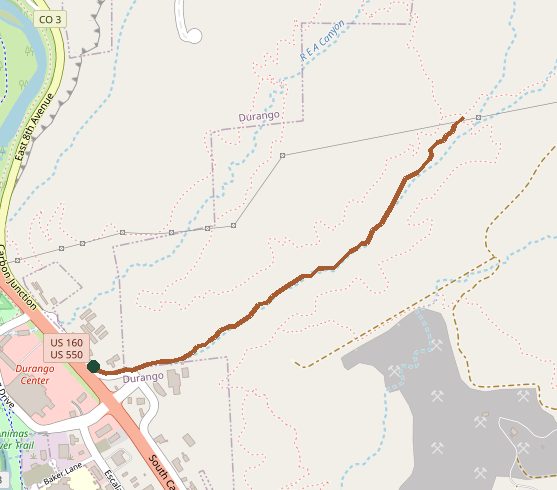
Trail layout from OpenStreetMap. This line is Big Canyon Trail, the usual way into the Grandview system. Map data © OpenStreetMap contributors.
Length and climb come from Durango Trails. A system with several trails lists each one above.