Hiking
Hermosa Area Trail System
The long Hermosa Creek country: Jones Creek, Pinkerton, upper Hermosa, Bolam Pass, and Hotel Draw. This is a system, not one loop.
- Length
- 105 miles
- Elevation gain
- Climbs run from about 1,700 to 4,000 feet
- Difficulty
- Advanced, Beginner, Expert, Intermediate
- From Durango
- 35 miles
Getting there
Hermosa Creek Northern Access Trailhead Hermosa Creek Southern Access Trailhead To main access point: To access Hermosa Road (upper road by Purgatory): Start at Purgatory Resort and park and ride up the road or shuttle to the top parking lot at Hermosa. To access Hermosa Creek Trail Out & Back: Take Highway 550 North from Durango and turn left at Hermosa Park Road. Cross the railroad tracks and follow up the road to the southern Hermosa Creek Trailhead located about 4 miles up Lower Hermosa Road, which starts near the railroad track crossing in the small town of Hermosa north of Durango. Find the trail heading north near the junction of several dirt roads near the parking spot.
The trails
Each path in the system has its own tile. Length and climb sit underneath. Hover a tile for what the trail actually does. Pick a rating to see only those.
Intermediate
- IntermediateMitchell Lakes TrailLocated just 15 miles north of Durango along Highway 550, the Mitchell Lakes Trail starts at County Road 250 at...
8.2 Miles · 2850 Feet of climbing
Located just 15 miles north of Durango along Highway 550, the Mitchell Lakes Trail starts at County Road 250 at...
Advanced
- AdvancedBig LickGetting to Big Lick : Access is from Elbert Creek Trail to the intersection sign shown here, then head onto Big...
6 Miles · 1700 Feet of climbing
Getting to Big Lick : Access is from Elbert Creek Trail to the intersection sign shown here, then head onto Big...
- AdvancedCorral Draw TrailCorral Draw trail connects the main Hermosa Creek trail to the Colorado Trail (at high country) near the...
5.3 Miles · 2500 Feet of climbing
Corral Draw trail connects the main Hermosa Creek trail to the Colorado Trail (at high country) near the...
- AdvancedBolam Pass RoadHotel Draw/Corral Creek/Hermosa Creek Loop: To access Hotel Draw / Colorado Trail / Corral Draw / Hermosa Creek...
Part of the
Hotel Draw/Corral Creek/Hermosa Creek Loop: To access Hotel Draw / Colorado Trail / Corral Draw / Hermosa Creek...
- AdvancedHotel Draw RoadHotel Draw Road can be reached from Hermosa Park Road on the backside of Purgatory Resort.
Part of the
Hotel Draw Road can be reached from Hermosa Park Road on the backside of Purgatory Resort.
- AdvancedSalt Creek West to Rico-Silverton TrailSalt Creek Trail connects from the Southern end of Hermosa Creek Trail into the Colorado Trail.
15 Miles · 3000 Feet of climbing
Salt Creek Trail connects from the Southern end of Hermosa Creek Trail into the Colorado Trail.
- AdvancedWest Cross Creek TrailWest Cross Creek Trail is a difficult 5.7-mile trail in the Hermosa Creek area.
5.7 Miles · 3430 Feet of climbing
West Cross Creek Trail is a difficult 5.7-mile trail in the Hermosa Creek area.
- AdvancedJones Creek TrailJones Creek / Pinkerton-Flagstaff / Dutch Creek Loop: To access Jones Creek / Pinkerton-Flagstaff / Dutch Creek...
4.2 Miles · 1850 Feet of climbing
Jones Creek / Pinkerton-Flagstaff / Dutch Creek Loop: To access Jones Creek / Pinkerton-Flagstaff / Dutch Creek...
- AdvancedGoulding Creek TrailGoulding Creek is best in September and early October, when the aspens turn.
3 Miles · 2300 Feet of climbing
Goulding Creek is best in September and early October, when the aspens turn.
- AdvancedPinkerton-Flagstaff TrailJones Creek / Pinkerton-Flagstaff / Dutch Creek Loop: To access Jones Creek / Pinkerton-Flagstaff / Dutch Creek...
8 Miles · 2660 Feet of climbing
Jones Creek / Pinkerton-Flagstaff / Dutch Creek Loop: To access Jones Creek / Pinkerton-Flagstaff / Dutch Creek...
- AdvancedDutch Creek TrailJones Creek / Pinkerton-Flagstaff / Dutch Creek Loop: To access the Jones Creek / Pinkerton-Flagstaff / Dutch...
11 Miles · 2500 Feet of climbing
Jones Creek / Pinkerton-Flagstaff / Dutch Creek Loop: To access the Jones Creek / Pinkerton-Flagstaff / Dutch...
- AdvancedLittle Elk TrailLittle Elk Creek Trail is an 11-mile difficult trail and it joins from Dutch Creek trail to the main Hermosa Creek...
11.1 Miles · 3900 Feet of climbing
Little Elk Creek Trail is an 11-mile difficult trail and it joins from Dutch Creek trail to the main Hermosa Creek...
- AdvancedElbert Creek TrailThe views from Purgatory Cliffs at the top of the Elbert Creek trail overlooking the Needles are beautiful no...
9.7 Miles · 4000 Feet of climbing
The views from Purgatory Cliffs at the top of the Elbert Creek trail overlooking the Needles are beautiful no...
- AdvancedHermosa Creek TrailThere are several route options including an there and back on the singletrack portion of Hermosa Creek Trail.
19.1 Miles · 2330 Feet of climbing
There are several route options including an there and back on the singletrack portion of Hermosa Creek Trail.
Where it is
The pin marks the trailhead. Map data © OpenStreetMap contributors.
Trail layout
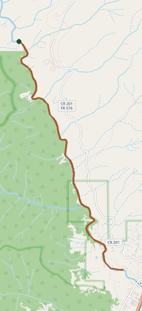
Trail layout from OpenStreetMap. This line is Hermosa Creek Trail, not the whole 105-mile system. Map data © OpenStreetMap contributors.
Length and climb come from Durango Trails. A system with several trails lists each one above.