Hiking
Missionary Ridge Trail System
A quieter ridge east of town. Durango Trails calls it moderate to expert, and a lot of locals still have not walked it.
- Length
- 28 miles
- Elevation gain
- Climbs run from about 1,650 to 3,560 feet
- Difficulty
- Advanced, Expert, Intermediate
- From Durango
- 10 miles
Getting there
Missionary Ridge Access at Silver Mesa Drive Haflin Creek Parking Area To main start of the trail: Drive 4.3 miles on CR 240 east from its junction with East Animas Road, to the first entrance of Durango Hills subdivision. Make a left on paved CR 249 and set your odometer to 0.0. At 0.3 miles, make a left on Nusbaum. At 1.0 miles, go straight on Stagecoach and FS 071. At miles 2.0, make a left and downhill, passing a spur to the right. Follow FS 071 signs to the top. At 2.2 miles, make a right on Silver Mesa, then continue straight on Silver Mesa at 2.6. At 3.0, you’ve reached the start of the trail. Or, if you prefer to hike UP: (Watch for downhill bikes) At U.S. Highway 550 and Trimble Lane (County Road 252), zero-out your trip meter and drive east. At 0.9 mile, make a left/north on East Animas Road (County Road 250). At 3.6 miles, make a right at the Stevens Creek Trailhead. There is room for only one vehicle. Drop a car and head back south on County Road 250. The roomy lot for the Haflin Creek Trailhead is on the left at 7.5 miles. Alternatively, if you wish to go directly to Haflin leaving Durango, it is 5.4 miles north from the corner of East Animas Road and Florida Road (County Road 240), on the right.
The trails
Each path in the system has its own tile. Length and climb sit underneath. Hover a tile for what the trail actually does. Pick a rating to see only those.
Intermediate
- IntermediateRed Creek TrailRed Creek Trail is a moderate 4.4-mile trail that can be reached from Missionary Ridge Trail or Red Creek Trail.
4.4 Miles · 2100 Feet of climbing
Red Creek Trail is a moderate 4.4-mile trail that can be reached from Missionary Ridge Trail or Red Creek Trail.
- IntermediateFirst Fork TrailFirst Fork Trail is a moderate 3.5-mile trail that can be reached from Missionary Ridge Trail or Red Creek Trail.
3.5 Miles · 1650 Feet of climbing
First Fork Trail is a moderate 3.5-mile trail that can be reached from Missionary Ridge Trail or Red Creek Trail.
Advanced
- AdvancedSteven’s Creek TrailSteven’s Creek Trail is a 7.25-mile trail near the north end of Missionary Ridge trail system.
7.3 Miles · 3560 Feet of climbing
Steven’s Creek Trail is a 7.25-mile trail near the north end of Missionary Ridge trail system.
- AdvancedMissionary Ridge TrailMissionary Ridge Trail is a 9-mile difficult trail along the top of Missionary Ridge.
9 Miles · 2600 Feet of climbing
Missionary Ridge Trail is a 9-mile difficult trail along the top of Missionary Ridge.
Expert
- ExpertHaflin Creek TrailHaflin Creek to Missionary Ridge is a good half-day, advanced hike, bike or horseback through the dramatic...
3.9 Miles · 3000 Feet of climbing
Haflin Creek to Missionary Ridge is a good half-day, advanced hike, bike or horseback through the dramatic...
Where it is
The pin marks the trailhead. Map data © OpenStreetMap contributors.
Trail layout
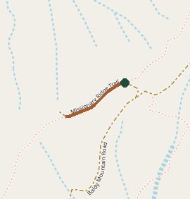
Trail layout from OpenStreetMap. The line is the mapped path that matched this name. A large system may show one path, not every loop. Map data © OpenStreetMap contributors.
Length and climb come from Durango Trails. A system with several trails lists each one above.