Hiking
Twin Buttes Trail System
A multi-use system just west of downtown. Popular with bikes, and open to hiking.
- Length
- 12 miles
- Elevation gain
- 700 ft
- Difficulty
- Advanced, Beginner, Intermediate
- From Durango
- 2.5 miles
Getting there
Twin Buttes Trailhead Parking From Durango, go west on Highway 160. After about 1.5 miles watch for a dirt parking lot near the Speedway gas station on the North side of the road. Turn right into the trailhead parking lot. You can also keep following Hwy 160 to the second access trail which is on Lightner Creek Road (CR 207).
The trails
Each path in the system has its own tile. Length and climb sit underneath. Hover a tile for what the trail actually does. Pick a rating to see only those.
Beginner
- BeginnerLightner Creek TrailLightner Creek Trail is a future paved trail, in collaboration with the City of Durango.
1.8 Miles · 422 Feet of climbing
Lightner Creek Trail is a future paved trail, in collaboration with the City of Durango.
Intermediate
- IntermediateCliffrock LoopCliffrock Loop climbs moderately through piñon and juniper, then flattens through meadows.
2.5 Miles · 450 Feet of climbing
Cliffrock Loop climbs moderately through piñon and juniper, then flattens through meadows.
- IntermediateTwin Buttes East TrailTwin Buttes East is a trail with a gentle climb starting at the CDOT parking spot.
0.4 Miles · 235 Feet of climbing
Twin Buttes East is a trail with a gentle climb starting at the CDOT parking spot.
- IntermediateMid Traverse TrailMid Traverse is an easy, flat trail in the Twin Buttes trail system.
1 Miles · 151 Feet of climbing
Mid Traverse is an easy, flat trail in the Twin Buttes trail system.
- IntermediateLower BC & F TrailLower BC & F trail follows the old railroad grade in the Twin Buttes area.
1.1 Miles · 306 Feet of climbing
Lower BC & F trail follows the old railroad grade in the Twin Buttes area.
- IntermediateUpper BC & F TrailUpper BC & F trail follows the old railroad grade in the Twin Buttes area.
1.1 Miles · 320 Feet of climbing
Upper BC & F trail follows the old railroad grade in the Twin Buttes area.
- IntermediateLower Ed & Flo TrailLower Ed & Flo Trail is a fun downhill with tight switchbacks, banked turns and whoop-de-dos.
0.7 Miles · 320 Feet of climbing
Lower Ed & Flo Trail is a fun downhill with tight switchbacks, banked turns and whoop-de-dos.
- IntermediateThe Buttes TrailThis trail offers a gentle climb then steep switchbacks in the Ponderosa forest leading to the base of the Buttes.
0.7 Miles · 315 Feet of climbing
This trail offers a gentle climb then steep switchbacks in the Ponderosa forest leading to the base of the Buttes.
Advanced
- AdvancedTwin Buttes TrailTwin Buttes Trail is a popular, difficult route in the Twin Buttes trail system.
1.9 Miles · 650 Feet of climbing
Twin Buttes Trail is a popular, difficult route in the Twin Buttes trail system.
- AdvancedUpper Ed & Flo TrailUpper Ed & Flo is a well-used trail in Twin Buttes because it offers a fun and whoopy downhill.
1.3 Miles · 420 Feet of climbing
Upper Ed & Flo is a well-used trail in Twin Buttes because it offers a fun and whoopy downhill.
Where it is
The pin marks the trailhead. Map data © OpenStreetMap contributors.
Trail layout
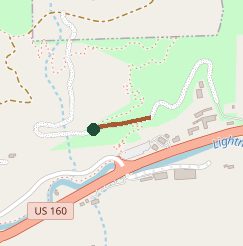
Trail layout from OpenStreetMap. The line is the mapped path that matched this name. A large system may show one path, not every loop. Map data © OpenStreetMap contributors.
Length and climb come from Durango Trails. A system with several trails lists each one above.