Hiking
Colorado Trail System (High Country)
The high-country end of the Colorado Trail in the San Juans. The mileage on the Durango Trails page is the full Denver-to-Durango route, not a day hike.
- Length
- 500 miles for the full Denver-to-Durango trail
- Elevation gain
- 89,354 ft for the full trail
- Difficulty
- Advanced, Expert, Intermediate
- From Durango
- 43 miles
Getting there
Molas Pass Parking Lot To access the Colorado Trail (High Country), take Highway 550 North from Durango for 42 miles. Turn right at Molas Lake and park in the Molas Lake Parking Lot. To access the Colorado Trail (Lower) , park at the Junction Creek Parking Lot.
The trails
Each path in the system has its own tile. Length and climb sit underneath. Hover a tile for what the trail actually does. Pick a rating to see only those.
Advanced
- AdvancedIndian Trail RidgeIndian Trail Ridge links the San Juan Mountains with the La Plata Mountain Range via the Colorado Trail .
12.5 Miles · 2620 Feet of climbing
Indian Trail Ridge links the San Juan Mountains with the La Plata Mountain Range via the Colorado Trail .
- AdvancedEngine Creek TrailEngine Creek Trail (FS#657) belongs to a loop for mountain biking and hiking.
3.4 Miles · 1900 Feet of climbing
Engine Creek Trail (FS#657) belongs to a loop for mountain biking and hiking.
- AdvancedRico-Silverton TrailThe route ascends two high mountain passes, thus affording wide views and good opportunities for photography.
2.4 Miles · 1828 Feet of climbing
The route ascends two high mountain passes, thus affording wide views and good opportunities for photography.
- AdvancedSharkstooth TrailSharkstooth Trail is a 6.6 mile (one way) trail to Sharkstooth Pass, with many wide views of Hesperus Mountain as...
6.6 Miles · 1932 Feet of climbing
Sharkstooth Trail is a 6.6 mile (one way) trail to Sharkstooth Pass, with many wide views of Hesperus Mountain as...
- AdvancedWalls Gulch Bridge TrailWalls Gulch Bridge Trail is near the iconic Colorado Trail in Southwest Colorado.
5.5 Miles
Walls Gulch Bridge Trail is near the iconic Colorado Trail in Southwest Colorado.
- AdvancedColorado Trail from Champion VentureThe High Country portion of the Colorado Trail can be reached from the trail’s southern terminus in Durango, Colorado.
500 Miles
The High Country portion of the Colorado Trail can be reached from the trail’s southern terminus in Durango, Colorado.
Other
- TrailMolas PassA well-used place for high country trail access just north of Durango, Molas Pass is a scenic overlook of...
Part of the
A well-used place for high country trail access just north of Durango, Molas Pass is a scenic overlook of...
Where it is
The pin marks the trailhead. Map data © OpenStreetMap contributors.
Trail layout
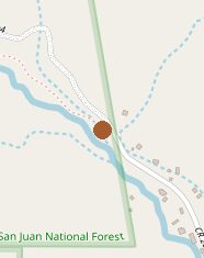
Trail layout from OpenStreetMap. The line is the mapped path that matched this name. A large system may show one path, not every loop. Map data © OpenStreetMap contributors.
Length and climb come from Durango Trails. A system with several trails lists each one above.