Hiking
Colorado Trail System (Lower)
The Durango end of the Colorado Trail, from the Junction Creek trailhead. This is the local piece, not the whole trail to Denver.
- Length
- 4 miles
- Elevation gain
- 1015 ft
- Difficulty
- Advanced, Intermediate
- From Durango
- 5 miles
Getting there
Lower Colorado Trail Parking To access the Junction Creek Trailhead from downtown Durango, travel north on Highway 550 (Main Avenue). Turn left hand turn at 25th Street (by the Exxon). The road will wind through a subdivision, becoming CR 204 (Junction Creek Road). At a three-way intersection, stay straight on CR 204, and follow this until you come upon a dirt parking lot and trailhead on your left. If this parking spot is full, continue along the dirt road for 1 mile to a secondary dirt parking spot near an intersection with the Lower Colorado Trail.
The trails
Each path in the system has its own tile. Length and climb sit underneath. Hover a tile for what the trail actually does. Pick a rating to see only those.
Intermediate
- IntermediateHigh PointThe High Point on the Colorado Trail is 10 miles from the Colorado Trail trailhead, it doesn’t not have a sign but...
7 Miles · 1500 Feet of climbing
The High Point on the Colorado Trail is 10 miles from the Colorado Trail trailhead, it doesn’t not have a sign but...
- IntermediateDry Fork TrailPopular among mountain bikers, trail runners, hikers and horseback riders, Dry Fork Loop is a popular singletrack...
3.9 Miles · 1330 Feet of climbing
Popular among mountain bikers, trail runners, hikers and horseback riders, Dry Fork Loop is a popular singletrack...
- IntermediateHoffheins TrailAfter hiking 4.05 miles along the Lower Colorado Trail to Gudy’s Rest you can turn left to head down Hoffheins and...
1.3 Miles · 442 Feet of climbing
After hiking 4.05 miles along the Lower Colorado Trail to Gudy’s Rest you can turn left to head down Hoffheins and...
- IntermediateColorado Trail at Junction CreekColorado Trail at Junction Creek The Colorado Trail at Junction Creek is one of the best trails in the Durango...
4.1 Miles · 1457 Feet of climbing
Colorado Trail at Junction Creek The Colorado Trail at Junction Creek is one of the best trails in the Durango...
Where it is
The pin marks the trailhead. Map data © OpenStreetMap contributors.
Trail layout
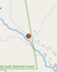
Trail layout from OpenStreetMap. The line is the mapped path that matched this name. A large system may show one path, not every loop. Map data © OpenStreetMap contributors.
Length and climb come from Durango Trails. A system with several trails lists each one above.