Hiking
Log Chutes Trail System
A multi-use system just above the Colorado Trail trailhead at Junction Creek.
- Length
- About 19 miles across the six trails
- Elevation gain
- Climbs run from about 660 to 1,600 feet
- Difficulty
- Advanced, Intermediate
- From Durango
- 6 miles
Getting there
Log Chutes Parking Lot (Junction Creek Road) The Log Chutes trailhead sits four miles past the Junction Creek Trailhead of the Colorado Trail. From Main Avenue (heading north) in Durango, turn left at 25th Street. The street turns into Junction Creek Road; continue west where you will see a sign for the Colorado Trail trailhead. Continue up the road four miles. The Log Chutes trailhead will be on your right.
The trails
Each path in the system has its own tile. Length and climb sit underneath. Hover a tile for what the trail actually does. Pick a rating to see only those.
Advanced
- AdvancedAnimas Overlook TrailAnimas Overlook is a well-used overlook for people to drive to (on Junction Creek Road) and enjoy a scenic view of...
2.9 Miles · 1400 Feet of climbing
Animas Overlook is a well-used overlook for people to drive to (on Junction Creek Road) and enjoy a scenic view of...
- AdvancedLog Chutes DownhillLog Chutes Downhill is one of the few Durango trails built to descend only.
1.7 Miles · 1200 Feet of climbing
Log Chutes Downhill is one of the few Durango trails built to descend only.
- AdvancedWestview LoopWestview Loop can be accessed where Log Chutes 3 crossed Junction Creek Road.
2.7 Miles · 660 Feet of climbing
Westview Loop can be accessed where Log Chutes 3 crossed Junction Creek Road.
- AdvancedLog Chutes 3Log Chutes 3 is a difficult, 3.75-mile trail accessed from Log Chutes 2.
3.8 Miles · 993 Feet of climbing
Log Chutes 3 is a difficult, 3.75-mile trail accessed from Log Chutes 2.
- AdvancedLog Chutes 2Log Chutes 2 is a difficult, 3.13-mile trail accessed from Log Chutes 1 or from the start of the trail and...
3.1 Miles · 784 Feet of climbing
Log Chutes 2 is a difficult, 3.13-mile trail accessed from Log Chutes 1 or from the start of the trail and...
- AdvancedLog Chutes 1Log Chutes 1 is a difficult, 4.8-mile “lollipop-style loop” trail.
4.8 Miles · 1600 Feet of climbing
Log Chutes 1 is a difficult, 4.8-mile “lollipop-style loop” trail.
Where it is
The pin marks the trailhead. Map data © OpenStreetMap contributors.
Trail layout
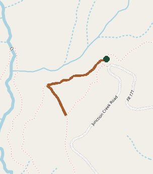
Trail layout from OpenStreetMap. The line is the mapped path that matched this name. A large system may show one path, not every loop. Map data © OpenStreetMap contributors.
Length and climb come from Durango Trails. A system with several trails lists each one above.