Hiking
Overend Mountain Park Trail System
About 300 acres on the west side of town. Close enough for an after-work hike, with several named trails inside the park.
- Length
- About 12 miles of trail in the park
- Elevation gain
- Climbs run from about 90 to 690 feet
- Difficulty
- Advanced, Beginner, Expert, Intermediate
- From Durango
- 2 miles
Getting there
Hidden Valley Circle Trailhead Crestview Street Trailhead Leyden Street Trailhead To reach the Hidden Valley Trailhead: From downtown Durango, travel north on Main Street to 22nd Street. Turn left on 22nd Street, then right onto West 3rd Avenue, then left onto 23rd Street. Follow that as it becomes Columbine Drive, then turn left onto Arroyo Drive. Make a left onto Hidden Valley Circle and parking will be at the end of the cul de sac. To reach the Crestview Street Trailhead: From downtown Durango, travel north on Main Street to 22nd Street. Turn left on 22nd Street, then follow it around as it becomes Montview Parkway. Make a right onto Highland Avenue, then turn left onto Crestview Drive. Parking is at the end of the cul de sac. To reach the Leyden Street Trailhead: From downtown Durango, travel north on Main Street to 22nd Street. Turn left on 22nd Street, then follow it around as it becomes Montview Parkway. Make a left onto Forest Avenue, then turn right on Leyden Street. Parking is at the end of the cul de sac.
The trails
Each path in the system has its own tile. Length and climb sit underneath. Hover a tile for what the trail actually does. Pick a rating to see only those.
Beginner
- Beginner8 Bells Trail8 Bells trail starts off Perin’s Gulch trail and meets Brown’s Ridge trail.
0.4 Miles · 200 Feet of climbing
8 Bells trail starts off Perin’s Gulch trail and meets Brown’s Ridge trail.
- BeginnerCrestview TrailCrestview Trail is often called “the ditch” and provides 0.6-miles of easy access along a rolling ditch to...
0.6 Miles · 120 Feet of climbing
Crestview Trail is often called “the ditch” and provides 0.6-miles of easy access along a rolling ditch to...
Intermediate
- IntermediateBrown’s Ridge TrailBrown’s Ridge trail accesses Hogsfoot and Hogsback trails as well as 8 Bells and Falcon Trail.
0.6 Miles · 240 Feet of climbing
Brown’s Ridge trail accesses Hogsfoot and Hogsback trails as well as 8 Bells and Falcon Trail.
- IntermediateFalcon TrailFalcon Trail is a moderate 1-mile loop in Overend Mountain Park that follows the drainage towards Leyden Street...
1 Miles · 308 Feet of climbing
Falcon Trail is a moderate 1-mile loop in Overend Mountain Park that follows the drainage towards Leyden Street...
- IntermediateSpirit TrailSpirit Trail starts off Ella Vita Court parking spot and is a popular moderate 1.9-mile trail in the southern end...
1.9 Miles · 520 Feet of climbing
Spirit Trail starts off Ella Vita Court parking spot and is a popular moderate 1.9-mile trail in the southern end...
- IntermediateElla Vita TrailElla Vita Trail starts off Ella Vita Court and connects to Brown’s Ridge, and into the Spirit Trail via Tech...
1.9 Miles · 450 Feet of climbing
Ella Vita Trail starts off Ella Vita Court and connects to Brown’s Ridge, and into the Spirit Trail via Tech...
- IntermediateHogsfoot TrailHogsfoot Trail sits in Overend Mountain Park trail system and provides access to Hogsback Trail from the Spirit...
0.8 Miles · 235 Feet of climbing
Hogsfoot Trail sits in Overend Mountain Park trail system and provides access to Hogsback Trail from the Spirit...
- IntermediateHogsback TrailHogsback Trail sits in Overend Mountain Park trail system and is a great day hike right in the town of Durango.
1.1 Miles · 690 Feet of climbing
Hogsback Trail sits in Overend Mountain Park trail system and is a great day hike right in the town of Durango.
- IntermediatePerin’s Gulch TrailPerin’s Gulch trail starts at Leyden Street start of the trail and follows Perin’s Gulch 1.2 miles up towards...
1.2 Miles · 390 Feet of climbing
Perin’s Gulch trail starts at Leyden Street start of the trail and follows Perin’s Gulch 1.2 miles up towards...
- IntermediateStar Wars DescentStar Wars is a fun and technical descent accessed from the top of Grabens Loop.
0.3 Miles · -240 Feet of climbing
Star Wars is a fun and technical descent accessed from the top of Grabens Loop.
- IntermediateNed’s Hill TrailNed’s Hill (named after Durangoan Ned Overend) can be reached from Grabens Loop, Perins Gulch, and Englehart’s trails.
0.5 Miles · 330 Feet of climbing
Ned’s Hill (named after Durangoan Ned Overend) can be reached from Grabens Loop, Perins Gulch, and Englehart’s trails.
- IntermediateEnglehart’s TrailEnglehart’s Trail starts off Hidden Valley and Crestview Trails.
0.4 Miles · 87 Feet of climbing
Englehart’s Trail starts off Hidden Valley and Crestview Trails.
- IntermediateGrabens LoopGrabens is a 0.6-mile segmented loop accessed from the top of Hidden Valley.
0.6 Miles · 115 Feet of climbing
Grabens is a 0.6-mile segmented loop accessed from the top of Hidden Valley.
- IntermediateHidden Valley TrailA well-used trail in Overend Mountain Park, Hidden Valley offers a winding and shaded hike or bike ride.
1.2 Miles · 480 Feet of climbing
A well-used trail in Overend Mountain Park, Hidden Valley offers a winding and shaded hike or bike ride.
Where it is
The pin marks the trailhead. Map data © OpenStreetMap contributors.
Trail layout
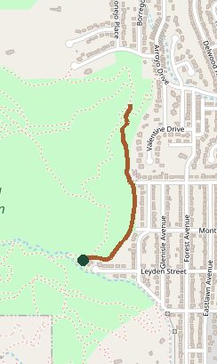
Trail layout from OpenStreetMap. This line is Crestview Trail inside the park, not every loop in the system. Map data © OpenStreetMap contributors.
Length and climb come from Durango Trails. A system with several trails lists each one above.