Hiking
Vallecito Lake Trail System
Year-round trails around Vallecito Lake, about 40 minutes from Durango. The page is a whole system, not one loop.
- Length
- 75 miles
- Elevation gain
- 3000 ft
- Difficulty
- Advanced, Beginner, Intermediate
- From Durango
- 29 miles
Getting there
Vallecito Lake Vallecito Lake sits 18 miles northeast of Durango. From Durango, take Florida Road (CR 240) out of town (approximately 16 miles). At the T-intersection, turn left on CR 501 which will bring you to the lake.
The trails
Each path in the system has its own tile. Length and climb sit underneath. Hover a tile for what the trail actually does. Pick a rating to see only those.
Beginner
- BeginnerThe Lake TrailsMost portions of the route skirt the edge of Vallecito Lake.
Part of the
Most portions of the route skirt the edge of Vallecito Lake.
- BeginnerPine River TrailThe Pine River alternates between meadows and canyon, frequently flowing peacefully on the flat valley floor.
23.2 Miles · 3000 Feet of climbing
The Pine River alternates between meadows and canyon, frequently flowing peacefully on the flat valley floor.
- BeginnerTuckerville TrailsFollow directions to Cave Basin Trail and continue to the end of road (11 miles) to an open area which was the...
Part of the
Follow directions to Cave Basin Trail and continue to the end of road (11 miles) to an open area which was the...
Intermediate
- IntermediateNorth Canyon, East Creek & Graham Creek TrailsThese trails follow the ridges on the east side of Vallecito Lake, following creeks with waterfalls to open meadows.
10.5 Miles · 3340 Feet of climbing
These trails follow the ridges on the east side of Vallecito Lake, following creeks with waterfalls to open meadows.
Advanced
- AdvancedVallecito Creek TrailA stunning day hike, or a great four-to-five day backpack trip.
3920 Feet of climbing
A stunning day hike, or a great four-to-five day backpack trip.
- AdvancedLake Eileen TrailThe four-mile round trip hike gains 1,140 feet in elevation and takes approximately four hours.
4.2 Miles · 1150 Feet of climbing
The four-mile round trip hike gains 1,140 feet in elevation and takes approximately four hours.
Expert
- ExpertCave Basin TrailDrive up Middle Mountain Road (USFS Road # 724 gravel) to the turn off at the ten mile marker.
5.4 Miles · 1720 Feet of climbing
Drive up Middle Mountain Road (USFS Road # 724 gravel) to the turn off at the ten mile marker.
Where it is
The pin marks the trailhead. Map data © OpenStreetMap contributors.
Trail layout
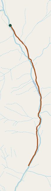
Trail layout from OpenStreetMap. This line is Vallecito Creek Trail, one route in a much larger system. Map data © OpenStreetMap contributors.
Length and climb come from Durango Trails. A system with several trails lists each one above.